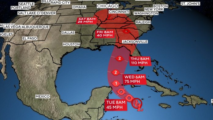
A developing storm in the Caribbean, potentially named Hurricane Helene, is expected to make landfall in Florida on Thursday.
Forecasters predict the system will strengthen into Tropical Storm Helene by early Tuesday, before moving into the Gulf of Mexico and intensifying into a hurricane by Wednesday morning.
The Ultimate Hiking Essentials: Top 10 Must-Have Items for Your Adventure
Hurricane watches have been issued for Tulum and Cancun in Mexico, as well as parts of Cuba.
The storm is projected to grow into a Category 2 or possibly Category 3 hurricane before hitting Florida’s Panhandle or Big Bend region on Thursday night. The main hazards include flash flooding, strong winds, and storm surge.
The areas of Tampa and the Florida Panhandle are likely to experience the most severe storm surge. Florida Governor Ron DeSantis has declared a state of emergency in 41 counties, urging residents to create emergency plans, know their evacuation zones, and prepare for the approaching storm.
Tropical storm watches have also been issued for the lower Florida Keys.

Once Helene makes landfall, the heavy rain and potential flash flooding could extend inland, impacting cities like Tallahassee, Atlanta, and Nashville. The region is expected to see 3 to 6 inches of rain, with isolated areas possibly receiving up to 10 inches.

